Saturday

RAJA AMPAT NATIONAL PARK PAPUA- Your Personal Disneyland of Diving Sites


Raja Ampat casts a spell on all who visit – scientists, photographers, novice divers and crusty sea-salts alike. This group of majestic islands, located in the northwestern tip of Indonesia’s Papuan “Bird’s Head Seascape,” lies in the heart of the coral triangle, the most bio-diverse marine region on earth.

As stunningly beautiful above water as it is below, Raja Ampat (which literally translates as “The Four Kings”) has a startling diversity of habitats to explore. Each of these – from the stark wave-pounded slopes that drop away beneath the karst cliffs of Wayag and Uranie to the deep, nutrient-rich bays of Mayalibit, Kabui and Aljui to the “blue water mangrove” channels of Kofiau and Gam to the plankton-rich upwelling areas of Misool and the Dampier Strait – are home to unique assemblages of species that, when taken together, add to produce the most impressive species lists ever compiled for a coral reef system of this size.
 
Marine tourism, as a sustainable alternative to overfishing, mining, and logging, has the potential to play a key role in the conservation of Raja Ampat’s spectacular underwater realm, while also creating real benefits for the local communities. This website was designed as part of a larger effort to support the growth of sustainable marine tourism in Raja Ampat and the conservation of these magical islands.

Please explore this site to find information on breathtaking diving opportunities, travel logistics, Raja Ampat’s new tourism entrance fee (which directly supports conservation and community development), and the tremendous conservation effort taking place in Raja Ampat. 

The roaring engines fixed to a large wooden boat are finally quiet. Nothing can be heard but the rifting little waves, lapping against the vibrant paint on the sides of the vessel that gracefully slows down. Native birds hop on the tip of a small tree in one of the deserted islands in the distance.

Raja Ampat or ‘Four Kings’, is the name given to these islands and comes from a local myth. The four major islands found here are Waigeo, Misool (which is home to ancient rock paintings), Salawati, and Batanta.
 

Underwater enthusiasts flock to this region because it offers the world’s best marine sights. Two days earlier, some of these travelers had been at a deafening corner of a tourist trap in Bali. Once they took their flight to the bird head of the island of Papua everything changed as they embarked on a diving tour of a lifetime. In the Raja Ampat islands, divers can explore vertical underwater walls. The thrill of drift diving is another great challenge. These are the awesome experiences you will find in Raja Ampat.

Meanwhile, on this tour several divers were well equipped and looked advanced. The territory within the islands of the Four Kings is enormous, covering 9.8 million acres of land and sea, home to 540 types of corals, more than 1,000 types of coral fish and 700 types of mollusks. This makes it the most diverse living library for world’s coral reef and underwater biota. According to a report developed by The Nature Conservancy and Conservation International, around 75% of the world’s species live here. When divers first arrive here their excitement is palpable. It’s common to hear people praise God as they take in the remarkable scenery. Others prefer to remain in silence taking in the overwhelming sight of so many islands with crystal clear water that softly brushes over the white sandy beaches.

“Disini bagus!”, says the friendly local guide who had been appointed by the tour operator who runs an eco-lodge in Raja Ampat, indicating that they have arrived at one of the most fantastic diving sites. On other days, this guide is just a simple fisherman. The local fishermen here are accustomed to foreigners and are friendly, especially when offered pinang (betel nuts) or some sweet candies. These are very popular and offering these sweets is considered polite and a good way to win an instant smile. The fishermen usually eat this snack during Para-para Pinang, or social chatting and exchanging funny stories while chewing Pinang. In many respects, like nature, culture, and history, these fishermen are closer to the Moluccas.
 

"No doubt about it, Raja Ampat is definitely the richest place for fish that I have ever been." -Dr G.R. Allen

"I was like a five-year-old, seeing a reef for the very first time. I was awestruck, held by the incredible power of this richest reef. We must, with all available resources, preserve the beauty of Raja Ampat. This may be the last frontier." --Michael Aw

"I love the people, I love the diving, it's super! I've never been for a second time to the same dive destination but now I'm thinking about going back for the third time! Should I say more?" --Peter van Dalen
 
 While the landscape may look like a dream, this is not an illusion. As you embark on your dive, the phrase ‘Attention to detail’ takes on new meaning as pigmy seahorses swim around your fingers. Manta Rays and wobbegongs will glide right by you. Tuna fish, giant trevallies, snappers, and even barracudas are there to complete your underwater ‘meeting list’. Not to mention the friendly assistant of the dugong, and a busy colleague, the turtle. Natural and untouched beauty is the main attraction here. With no unnecessary adages, the sky, the lush islands, the sea, and everything above and under it is genuinely saying ‘Welcome to Raja Ampat Islands; your personal Disneyland of diving sites’.


http://www.rajaampatsailing.com

Lake Sentani Festival


Papua or island known as Earth of bird paradise does have beautiful marine tourism no less other than areas in Indonesia. One of the most beautiful places in Papua is the Lake Sentani. Lake Sentani is 70-90 meters above sea level. Located also in the Cyclops Mountains and is a volcanic lake.

Source water comes from 14 large and small rivers with a single river mouths, the lake’s depth is very steep. Lake Sentani offers incredible Scenery. If you visit the Lake Sentani, you will find some of Crane and the Eagles are going to grab a fish in Lake Sentani.

Sentani city located in Jayapura has lots of natural beauty. In order for indigenous values and culture, the art of the tribes around Lake Sentani region doesn’t come to fade, then the Sentani Cultural festival held deemed necessary. Lake Sentani Cultural Festival held each year in the kalkote Region Tourism-lake Sentani, Jayapura regency, Papua. This event is a cultural festival from several villages around Lake Sentani and several districts in Papua as an effort to support government programs to increase tourist visits Indonesia.

The Lake Sentani Festival is one of three major festivals in Papua, besides the Baliem Valley Festival held in August and the Asmat Festival in October, that together offer the best and most comprehensive presentations of the island, according to information on the official Indonesian tourism website www.Indonesia.travel.

This year is the seventh year of the implementation of the Lake Sentani Festival, and this year, Lake Sentani Festival was held on June 19th -23th, 2014 near Sentani Airport and the capital of the province of Papua, Jayapura. The increasing of tourists to Papua occur  from year to year.

At this festival will be displayed a unique cultural heritage, such as War Dance on the boat and other traditional dances from various exists tribe in Jayapura. At this festival also celebrated by Papua’s other cultures and other areas in Indonesia which have similar characteristics with Lake SentaniWelcome to Sentani lake festival in June every year.

One of my favourite dance is Isosolo Dance. Isosolo dance is a traditional war dance performed in the traditional boat. Hundreds of dancers wearing the traditional costume with bows and arrows danced and sang along the Sentani Lake to Khalkote Beach in the fifteen decorative traditional boats. The dancing has turned a magnet for the visitors during the ceremony. It was unique dance. The dance was very attractive, energetic, and powerful, further it performed in the traditional boat on the Lake Sentani.


Come and Join in the The Lake Sentani Festival, feel the great emotion.

Thursday

Ancient Animals is still Living In Indonesia

Indonesia, actually is quite amazing because in this country  still found a variety of unique ancient animals. Their population is few and the sustainability must be protected. Here are ancient animals that still exist in Indonesia. You can tour and explore Indonesia to find them.

1 Komodo

Komodo also know as the Komodo dragon (Varanus komodoensis),  or the Komodo monitor, is a large species of lizard found in the Indonesia islands, named of komodo Island. Komodo growing to a maximum length of 3 metres (10 ft) in rare cases and weighing up to approximately 70 kilograms (150 lb).

As a result of their size, these lizards dominate the ecosystems in which they live. Komodo dragons hunt and ambush prey including invertebrates, birds, and mammals. It has been claimed that they have a venomous bite; there are two glands in the lower jaw which secrete several toxic proteins. The biological significance of these proteins is disputed, but the glands have been shown to secrete an anticoagulant. Komodo dragon group behaviour in hunting is exceptional in the reptile world. The diet of big Komodo dragons mainly consists of deer, though they also eat considerable amounts of carrion. Komodo dragons also occasionally attack humans in the area of West Manggarai Regency where they live in Indonesia.

Komodo dragons were first recorded by Western scientists in 1910. Their large size and fearsome reputation make them popular zoo exhibits. In the wild, their range has contracted due to human activities, and they are listed as vulnerable by the IUCN. They are protected under Indonesian law, and a national park, Komodo National Park, was founded to aid protection efforts.

2  Leatherback sea turtle
The leatherback sea turtle (Dermochelys coriacea), sometimes called the lute turtle, is the largest of all living turtles and is the fourth heaviest modern reptile behind three crocodilians. It is the only living species in the genus Dermochelys. It can easily be differentiated from other modern sea turtles by its lack of a bony shell. Instead, its carapace is covered by skin and oily flesh. Dermochelys coriacea is the only extant member of the family Dermochelyidae.

Leatherback turtles can be found primarily in the open ocean. Scientists tracked a leatherback turtle that swam from Indonesia to the U.S. in an epic 20,000 km (12,000 mi) foraging journey over a period of 647 days. Leatherbacks follow their jellyfish prey throughout the day, resulting in turtles "preferring" deeper water in the daytime, and shallower water at night (when the jellyfish rise up the water column). This hunting strategy often places turtles in very frigid waters. One individual was found actively hunting in waters that had a surface temperature of 0.4 °C (32.7 °F).

3.  Arowana
Arowanas are freshwater bony fish of the family Osteoglossidae, also known as bonytongues. In this family of fish, the head is bony and the elongated body is covered by large, heavy scales, with a mosaic pattern of canals. The dorsal and anal fins have soft rays and are long based, while the pectoral and ventral fins are small. The name "bonytongues" is derived from a toothed bone on the floor of the mouth, the "tongue", equipped with teeth that bite against teeth on the roof of the mouth. The arowana is a facultative air breather and can obtain oxygen from air by sucking it into its swim bladder, which is lined with capillaries like lung tissue.

Arowana fish is one of the ancient fish that has not extinct yet. Studies of genetic and fossil findings show, these fish have been living on the earth at least since 220 ​​million years ago. Arowana is the carnivorous fish inhabiting the river and lake habitats. These fish can be found in the Amazon, and in parts of Africa, Asia and Australia. Arowana Fish (Scleropagus sp.) Can be found in freshwater Indonesia. One kind of Arowana is a super red and can be found in Kapuas River and Sentarum Lake in West Kalimantan . These waters are areas of peat forest creates a primitive environment for these ancient fish.

4. Saltwater crocodile
The saltwater crocodile (Crocodylus porosus), also known as saltie, estuarine or Indo-Pacific crocodile, is the largest of all living reptiles, as well as the largest terrestrial and riparian predator in the world. The males of this species can reach sizes of up to 6.7 m (22 ft) and weigh as much as 2,000 kg (4,400 lb)

saltwater crocodile  can be found ranging from the Bay of Bengal (India, Sri Lanka, and Bangladesh) to the Fiji Islands. Indonesia became a favorite habitat for saltwater crocodile  beside Australia.

5. Pangolin
A pangolin  (also referred to as a scaly anteater or trenggiling) is a mammal of the order Pholidota. The one extant family, Manidae, has one genus, Manis, which comprises eight species. A number of extinct species are also known. A pangolin has large keratin scales covering its skin, and is the only known mammal with this adaptation. It is found naturally in tropical regions throughout Africa and Asia. The name pangolin comes from the Malay word pengguling, meaning "something that rolls up".


Pangolins are nocturnal animals who use their well-developed sense of smell to find insects. The long-tailed pangolin also is active by day. Other species of pangolins spend most of the daytime sleeping, curled up into a ball.


Arboreal pangolins live in hollow trees, whereas the ground dwelling species dig tunnels underground, to a depth of 3.5 metres (11 ft). Pangolins are also good swimmers. 

Mount Bromo


Mount Bromo is active volcano and most famous as a tourist attraction in East Java, Indonesia. That is why Mount Bromo become popular and attractive because of its status as the active volcano, with a height of 2392 meters above the surface, covering regions, namely Probolinggo, Pasuruan, Lumajang and Malang.

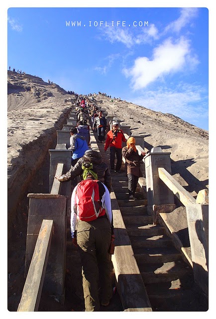
Mount Bromo has a crater with a diameter of ± 800 meters. You have to walk quite a distance to achieve the crater, Walk from the parking area to the Bromo crater must be reached along the 2 km and have to climb 250 stairs.


Sometimes Mount Bromo spit  up gas named fumaroles. The gas fumes smelled like sulfur with gust as high as 60 to 80 feet above the top of the mountain. This type of gas containing water vapor. Inhalation of this gas in large quantities can be bad for health.

Temperatures range between 3 ° -20 ° Celsius on Mount Bromo, but it can be a few degrees below zero during the dry season. If you are not stand with the cold air, you'd better bring a jacket, gloves, and hats or other head coverings. After sunrise the weather is becoming quite hot here.


Tengger people live in the area of Mount Bromo, they believe that Mount Bromo is a place where a prince sacrificed life for his family. People here do "Yadnya Kasada" or "Kasodo" festival once a year with the dedication of vegetables, chicken, and the money thrown into the volcano crater to sacrifice to the gods. If you want to see the festival, just come to Kasada festival in September-November each year.

From the peak of Bromo crater you will see the phenomenon active volcanic mountain. Visitors also can see a very wide stretch of sand, and become more amazing at daylight.

From the top of Mountain, you can watch a beautiful sunrise.  The scenery is amazing and you can not get it anywhere else.

List of Hotels in Bromo

Here's a list of hotels available in Bromo tourism area that you can stay
- Cafe Lava Hotel, Its location close to the entrance of the Bromo Tengger Semeru National Park (TNBTS).

- Cemara Indah Hotel and Bromo Permai Hotel, These hotel have direct view to the Mount Bromo and the bathrooms are equipped with hot water.

Other hotels like the Bromo Permai 1 Hotel, Lava View Lodge Hotel is the most classy hotel in the area, Yoschi's Hotel with a distinctive feel of Bali, Sion View Bromo Hotel,  Nadia Sukapura Bromo Hotel, Java Banana Bromo Hotel, and Primadona Sukapura Hotel, all of them can be your place to stay

Mount Bromo is located in the area of ​​Bromo Tengger Semeru National Park. These institutions are managing and responsible for the region of Mount Bromo. If you come to visited Mount Bromo, do not forget to contact them.

Address Bromo Tengger National Park at: Jl. Raden Intan number 6, Post Office Box 54, Malang Phone. (0341) 491828; Fax. (0341) 490885 and Jalan Panda number 8, Malang phone. (0341) 551 040 East Java. Indonesia.


Sunday

Lawang Sewu In Semarang


Lawang Sewu become one place or the building that most talked about in Semarang, Indonesia. Not because of the unique name, but also sometimes associate with the mystical.

Whatever it is, Lawang Sewu is a historic building, It has been become operational offices of government agencies, and now become one of the favorite tourist destinations in Semarang, Indonesia.

Lawang Sewu is a building in Semarang, Central Java, Indonesia, which was the office of the Nederlands-Indische Spoorweg Maatschappijatau NIS. Built in 1904 and completed in 1907. Located at the roundabout Tugu Muda, formerly called Wilhelminaplein.

Lawang Sewu was designed by C. Citroen, from the firm of J.F. Klinkhamer and B.J. Quendag. Construction began in 1904 with A building, which was completed in 1907. The rest of the complex was finished in 1919. It was initially used by the Nederlandsch Indische Spoorweg Maatschappij, the national railway of the Dutch East Indies.

The name Lawang Sewu is from Javanese; it means "Thousand Doors". The name comes from its design, with numerous doors and arcs. The building has about 600 large windows.

Lawang Sewu is loaded with historical events leading up to independence of Indonesia from Dutch colonial. When that happens the great battle in Semarang five days (October 14 to October 19 1945). This building was a silent witness to a great battle between the Young Generation Train (AMKA) against Kempeitai and Kidobutai, troops of the Japanese invaders.

After the independence of the Republic of Indonesia, Lawang Sewu building used as an office Djawatan Repoeblik Indonesian Railways (DKARI) or now known as PT. Kereta Api Indonesia (KAI).  Furthermore, once used by the military as the office of Infrastructure Agency Regional Military Command (military command IV / Diponegoro).


Lawang Sewu is said to be haunted, with many tourists visiting to see the ghosts. Among the ghosts reported to inhabit the establishment are a Dutchwoman who committed suicide inside and "headless ghouls”.

Saturday

Danau Sentarum National Park- Representative of Wetland Ecosystems


Danau Sentarum National Park is a national park protecting one of the world's most biodiverse lake systems,  located in the heart of Borneo Island, Kapuas Hulu Regency, West Kalimantan Province, Indonesia. The Danau Sentarum National Park is representative of wetland ecosystems lakes, freshwater swamp forest and tropical rain forest in Borneo. Approximately half of the park consists of lakes, while the other half consists of freshwater swamp forest.

The Danau Sentarum National Park (DSNP) ,is located in a remote area of the upper Kapuas River called "Kapuas hulu" in West Kalimantan province, of Indonesia Borneo, and situated close to the Malaysian border of Malaysian Sarawak, and is approximately 700 km. inland from the West Kalimantan provincial capital, Pontianak. The Danau Sentarum National Park is an area of connected big lakes and seasonally flooded by the tropical rains, as the water streams down from the cloud Rain Forest hills of the surrounding area.

The Danau Sentarum National Park is approximately 30-35 m. above sea level, while the surrounding hills are situated as high as 750 meter above sea level. Daytime temperatures are consistently between the 26-30 degrees Celsius, The driest months are usually July, August, and September. The area was established in 1985 as the Danau Sentarum Wildlife Reserve. While the borders are unclear, the main part of the park is around 1250 square km

Several Longhouses are found in the area of Danau Sentarum National Park, The Iban longhouse of Sungal Sedik is located about 6 km. from the district center of Lanjak. The longhouse was a 14-household community containing about 100 residents. The Sedik River territory is a hunted area for the members of the at least five other longhouse Dayak communities of Lanjak. 

West Kalimantan 's Danau Sentarum National Park wildlife has 120 species of fish, Among them are the Asian bony tongue, toman, betutu, jelawat, belida, ketutung, and the beautiful clown loach. Other animals like proboscis monkey, orangutan, estuarine crocodile, siamese crocodile, clouded leopard, great argus pheasant, false gavial, and wooly-necked stork also inhabit this national park.

Some locations / attractions to be visited:
Lanjak hills, Nanga Kenelang hill and Tekenang hill. A panoramic view of the lake, boating and wildlife observation and study of birds equipped laboratory facilities.

How to get  there :
To reach the location: Pontianak-Sintang-Semitau using a four-wheeled vehicle about 11 hours or Sintang-Semitau longboat (Bandong) taken about seven hours. Semitau to the location using the motor boat to Lanjak. Pontianak-Putussibau with aircraft about two hours and Putussibau to Nanga Suhaid with longboat about seven hours.

Easy way  touring this Indonesian secret place, you are be abe dealing with De'Gigant Tours™. They are the Trade Mark of the company named PT. Gigantara® as an under Indonesian Law Based Tourism Company, owned by  Lucas Zwaal and Drs. HS. Fathan who have more then 20 years experience in Hotel and Tourism Industry, specially at the Indonesian part of Borneo.
Office Address:
De'Gigant Tours™ ( PT.Gigantara® )
Jl. Martadinata Raudah 1 no 21
Samarinda, East Kalimantan, Indonesia
Phone +62 541 7091536
Fax +62 541 7778648
Hot Line +62 8125846578 ( 24 hours )
info@borneotourgigant.com


Background and Permits
Official Tourism Permit number : 556.7/1443/UPT/IX/2008
Company Permit number : 503/2668/729.G/BPPTSP-C/IX/2011
Company Tax number : 02.828.505.4.722.000
Company Employee Registration Number : 043602011

Satulingkar.com
Bumisme13.blgogspot.com


Thursday

Mount Rinjani


Mount Rinjani is 3,726 m, the second highest volcano in Indonesia, second only to Mount Kerinci on Sumatra, and it dominates the landscape of the relatively small island of Lombok.
Within its huge 50 km² caldera sits the crater lake Segara Anak (Child of the Sea). Eruptions within the caldera have formed a new small cone called appropriately enough, Gunung Baru (New Mountain). Segara Anak has a natural hot spring.

The mountain and its satellites form the Mount Rinjani National Park  - officially 41,000 hectares within the park boundaries and a further 66,000 hectares of protected forest outside.

Gunun Rinjani National Park lies within the major transition zone(Wallaceae) where the flora and fauna of South East Asia makes a dramatic transition into that which is typical of Australasia. The Park has a rich variety of plants and animals, although they can be hard to spot due to the terrain and rainforest cover.

Sometimes seen early in the mornings is the rare black Ebony leaf monkey, known locally as Lutung.

TheLong tailed grey macaque or Kera is common in Lombok and older males are seen on the crater rim. Rusa deer are forest dwellers and are occasionally seen along the Rinjani trek trail. The smaller Barking deer or Kijang has an alarm call with a distinct dog-like bark. Look for the disturbed ground where the Wild pig or Babi hutan has been foraging. Also found in the forest is the Leopard cat or Bodok alas, Palm civet or Ujat and Porcupine or Landak.

A variety of colourful birds live in the forests of the Park. Perhaps the best-known icon of the Park is the Sulphur Crested Cockatoo that is not found any further west of Lombok. Many of the forest-dwelling animals, insects, birds, civets and monkeys owe their survival to the wild fig tree or Beringin as a provider of food and shelter. The pine-like Casuarina species, Cemara, are a feature of the grassy higher slopes. Orchids or Anggrek are also a feature of the grassland areas, as is Edelweiss or Bunga Abadi growing above the tree line; it is a beautiful icon of the Park and one of our best-known sub-alpine plants.

Rinjani  Trek Centre: The Centre is located at the trailhead above Senaru traditional village and Rinjani Information Centre located at Sembalun Lawang village. They offer information and displays for visitors on the trek, the National Park, Sasak culture and a range of activities available in Senaru.

In 2008, the Indonesian government proposed to UNESCO that Mount Rinjani be one of the world's official geoparks. If this was approved by UNESCO, Mount Rinjani would become the first such geological park in Indonesia.

This mount is a very active volcano. The oldest recorded historical eruption was in 1847. Previous to that this was a very remote region indeed, hence the lack of records.
There was a spate of activity from 1994 to 1995 which resulted in the further growth of the crater cone Gunung Baru, since renamed Gunung Barujari (Finger Mountain).

On 27 April 2009 Gunung Barujari became active again with that activity continuing through to May 2009. The summit ascent routes were closed at that time as the eruptions intensified with plumes of smoke and ash as high as 8,000 m. A Volcanic Explosivity Index (VEI):2 rating was issued for the activity between May and December 2009. The ascent routes re-opened on September 14th 2009 but hiking routes down into the crater lake were still deemed unsafe and remained closed.

The lower and mid levels of the mountain are quite heavily forested. Above the tree line though the slopes are barren and rugged scree slopes and volcanic rock. The views of the crater lake are quite breath-taking from the caldera rim, as is the sunrise. From the absolute peak you can see Bali to the west and Sumbawa to the east.

The lower and middle elevation slopes are densely forested with typical tropical species, including species which occupy the Wallacea transitional region between the SE Asian and Australasian flora. Fig trees are especially apparent in the lower forests, as are the giant Syzigium Jambu, with the gnarled and epiphyte-hung Engelhardia Bak Bakan becoming prominent in the higher elevations. Casuarina woodland (cemara) takes over higher up and eventually these give way to an alpine flora above the treeline.

Lombok is East of the Wallace Line and some bird species with Australasian affinities are therefore apparent. These include honeyeaters, cockatoos and green hanging parrots, in addition to species whose heartland is to the West including tits, weavers and tailor-birds. Bird life can be difficult to observe here due to the density of the forest, though if you have patience and are practised at mimicry many species can be tempted out from cover - if you have the time to spare and the forebearance of your trekking partners.

The familiar long-tailed grey macaque (the Bali temple monkey) is common right up to the crater rim. Of much more interest is the rare ebony leaf monkey which inhabits these forests and whose soft hooting contact call often provides a soothing backdrop to the birdsong. Rusa deer and muntjacs are more often heard than seen.

Rinjani is best climbed during the April-November dry season. The trekking trails are generally closed during the rainy season. In recent years the early months of the 'dry season' have become more prone to rain and you should be prepared to encounter heavy rain and low visibility with slippery tracks underfoot at any time, particularly in the afternoon.
It gets very cold on the mountain above 2,000 m and nears freezing at the summit. Warm clothing is an absolute must.

Most visitors arrive via the village of Senaru  (600 m), on the northern side of the mountain and thus closer to the main resort areas of the west coast including Sengingi . The other possible entry point is Sembalun Lawang (1,150 m), on the eastern side, which is closer to the summit.
Both villages are accessed from the main north coast road.


Exotic Beaches In Lombok-NTT


If you wish to visit the exotic beaches and virgin, just come to Lombok,   East Nusa Tenggara- Indonesia. Here are some beaches that successfully gathered.

1 . Kuta Beach
As Kuta beach in Bali , Kuta beach in Lombok is also frequently visited by tourists both local and foreign . At certain times, the waves high enough and suitable used for surfing . If we go far enough to the east, a small mangrove forests have been waiting there . Boating around the small forest is very pleasant and good choice. This beautiful beach with beautiful views is located in the Kuta village, Pujut subdistrict, about 27 km to the south of the Praya city. The seawater inhabited by various species of fish and coral reefs that you can enjoy with swimming, snorkeling or diving . Sunbathe is a nice activity, it will make your skin brown. Not only five-star hotel here, but to the lower classes is available here, there is also some restaurants , cafes , surf guide and tourism security posts .

2. Seger Beach (The Legend of Princess Nyale Beach)
When going through the shoreline, Seger beach located very close to Kuta. However, when passing through the main road, it will becomes little bit longer to achieve the beach. Seger Beach is also known as a Princess Nyale beach, where every year around the month of February was held nyale scent rituals (bau nyale). The local citizen searching and catching sea worms that tastes very delicious. Many small hills on the Seger beach, that you can climb and enjoy the beautiful scenery around.

3. Tanjung Aan Beach (The Charm Beach)
The location is not far from the beach of Kuta beach. It is only 3 km towards the east. The atmosphere is certainly beautiful and natural, so that visitors can spend time at the beach for swimming, fishing, and sunbathing. This beach has relatively quiet wave characteristics. In the east side, the long beaches with sand-sized grains of yellow pepper, as it is often called sand pepper. While the west side, separated by a small cape, there is a beach longer than the other side with a grain size of very fine sand like white flour.

4. Gerupuk Beach
It is called Gerupuk beach because it is located in village Gerupuk, just 9 km from Kuta to the east. The locals are fishermen, seaweed cultivation, and fish farmers, sometimes They will rent their boat when visitors want to. Gerupuk beach is very famous surfing spot even the best, because the waves are always great throughout the season. This area is equipped with accommodation facilities, bungalows, restaurants, cafes and security posts.

5. Mawun Beach
The beach is like a bow-shaped bay with a deep arch. The hills that flank the beach changes its color when the seasons changes. In the rainy season, the green vegetation is dominated, but while in the dry season the hills will look a brownish color. This beach has a fine sand like flour, especially in the middle.

For everybody who has adventurous soul, a hill which is quite high and steep climb has been waiting for. At the top of the hill, enchanting views  is available to enjoy. Becouse the Mawun beach is flanked by cliffs, the wave is very quiet and almost no waves so it is very comfortable to swim and enjoy the freshness of the sea water.

6. Selong  Belanak Beach

This beach is place of fishermen home, they have many colorful boats are moored. The beach is located in village Selong Belanak, West Praya districts only 34 Km from the city of Praya. The uniqueness of this beach is white sand that shiny when exposed to the heat of the sun. If visitors want to bake sea fish, just wait untill the fishermen back from sea, especially in the morning, they will back with many kind of fish. You can enjoy your fish and make unforgetable vacation.

Wednesday

Tsunami Tourism Place in ACEH


Banda Aceh is the Provincial Capital of Aceh Province, formerly known as Kutaraja until 1962. On April 22nd, 2013 Banda Aceh celebrates its 808 years anniversary. Today, Banda Aceh is the beating heart of the Provincial Goverment administration for economic, cultural and tourism development.  Banda Aceh has fully recovered from the December 2004 tsunami boxing day which destroyed almost 60% of the city with approximately 75.000 victims. Kutaraja or Banda Aceh as the capital of the Islamic Kingdom of Aceh Darussalam is one of the oldest Islamic city in South East Asia.

Earthquake occurs at 7: 58: 53 am. Earthquake center located in longitudes 3.316° N 95.854° at least 160 miles west of aceh at depths 10 kilometers. This earthquake measuring 9.3 richter scale and is an most intense earthquake in the last 40 years that impacted Aceh, the west coast of peninsula Malaysia, Thailand, the east coast of India, Sri Lanka, even up the east coast of Africa. Aceh as city that casualty the world biggest and thousands of building destroyed, thousands of also lost a corpse is not found and thousands also geeks in interred in public.

In Indonesia, a quake swallows more than 170,000 fatalities. About 250,000 people in 13 countries died in the tsunami disaster, which occurred after the earthquake in the Indian Ocean. Dozens of houses were destroyed by the earthquake, mainly in Meulaboh and Banda Aceh on the tip of Sumatra island. In Banda Aceh, about 50% of all buildings were damaged by the tsunami. However, most of the casualties were caused by the tsunami that struck the West coast of Aceh and North Sumatra.

Now the disaster has passed, Aceh has risen to re-arrange everything has been damaged over the disaster. Aceh, located in the westernmost region of the Republic of Indonesia with its natural beauty and cultural attractions as well as the richness of the history of the past has been prepared to promote Aceh through the tourism industry in a sustainable and environmentally with fixed characteristics of mengkedepankan area, in particular the development of tsunami tourism with many relics of the tsunami.

The existence of the Museum as a Tsunami museum in Aceh and international community pride, in addition to being a symbol of the strength and patience of the people of Aceh in the face of the tsunami disaster, also became an icon of tourism Aceh tsunami. The Museum was built by the architectural approach to the culture of Aceh with various collections and events of the tsunami, such as documentary film/4 dimensions, cartoons, paintings, hikayat Aceh Tsunami, poetry, short stories, plays, music or song, the story of ”Smong Semeulue 1907” and other local wisdom became the attraction and learning media effectively for travelers.


This museum was built with the concept of stilts-house as the typical of Rumoh Aceh (Acehnese traditional house) that can be used as an escape building during a flood or tsunami. Inside you can find a variety of dioramas of tsunami, some photographs about tsunami when it happened and after tsunami, earthquake simulation room, 4 dimensions audio visual equipment. All of them brought us the feeling of the real moments of earthquake. Besides that you could enjoy the cozy and pleasant place.

The “Thanks The World” Monument
Tsunami Monument "Aceh Thanks the World", is located in the Garden City of Blang Padang, in area of ​​8 hectares, is a symbol of Acehnese gratitude to the volunteers, NGOs, state higher institutions, corporate, civil, and military both national and international who have participated in Aceh construction after the Tsunami disaster. This monument has a lot of stories, It become more popular lately. This monument shaped the tsunami waves.

Acehnese people express their gratitude to the country contributed to Aceh rehabilitation and reconstruction through the inscription of friendship. On the inscription is written the name of the state, state flag, and gratitude expression ‘Thank You and Peace’ in the language of each country. There are 53 inscriptions in Blang Padang field. Blang Padang now days is an open public places to do excercise and relaxation. There are jogging track, soccer field, basketball, and the pillars to do the mild fitness. Every weekend, this field become a family favorite spot. On this area is also available a variety of culinary/snacks. Apart from the Monument, Acehnese people express their gratitude to the country that through the inscription of friendship.


PLTD Apung (Electrical Generator Ship)
Before the PLTD Apung is situated in current position, it was moored in the port of Ulee Lheue. The ship was pushed on to land as far as 2,5 km from the coast of Ulee Lheue by the Tsunami and set down in the middle of Punge Blang Cut village. According to the mouth to mouth story, many people survive from the wave by riding this boat. Today this electricity diesel no longer works to supply the electrical crisis. It now turns to be a historical site of Tsunami.


Fishing Boat on the Roof
A fishing boat is held on an inhabitant house and managed to save 59 souls by boarding on it, when the Tsunami’s wave hit Lampulo village. Because it has historical values, now the boat is used as an important monument to commemorate the enormity of the tsunami.

Mass Grave
Mass graves located in a number of places in Banda Aceh. The big one is in in Siron village, Lambaro, Aceh Besar. Number of fifty thousand people of tsunami victims were buried in here. Lambaro Tsunami Mass Grave has become a witness of Mega Earthquake and Tsunami Disaster in the last December 2004. Besides mass grave Siron, there are also other mass graves located in Ulee Lheue and Lhoknga.

Baiturrahim Mosque
In many settlements of coastal Aceh destroyed by the tsunami, the mosque was usually the only building that survived. This was the case with the old mosque of Ulee Lheue. This building survived the Tsunami and it can still function as a mosque and gathering place. Some of the damaged parts have been renovated. The highlight of the  commemoration of the 1st year of Tsunami was held in this mosque


Hotels
At Hotel like hotel Medan on the street Medan. A. Yani Number 17 Peunayong - Banda Aceh also displayed photographs stunami events. How does a ship stranded and embedded just in front of the hotel and many car piled, will add a strong impression of how tsunami occured

If you visit Aceh, these are hotels that you can stay for

1. Hermes Palace Hotel Banda Aceh 
Jln.T.Panglima Nyak Makam, Banda Aceh.
Telp: +62 651 755 5888 Fax.: +62 651 755 6999

2. Hotel Grand Nanggroe Jl. T. Imum Lueng Bata, Kel. Cot Mesjid, Kec Lueng Bata. Banda Aceh
Telp: +62 651 35788  Fax.: +62 651 35778
Website:
www.grandnanggroehotel.com

3. Sulthan Hotel International  
Situated in the city of Aceh, Sulthan Hotel International is just a 5-minute drive from the Aceh Traditional Market. It houses a restaurant and offers free Wi-Fi access throughout its premises.
The hotel is a 10-minute drive to Hermef Mall and a 15-minute drive to Ulele Beach. The Sultan Iskandar Muda International Airport is a 25-minute drive away.

4. Hotel Medan.  
Jl. A. Yani No. 17 Peunayong - Banda Aceh
Phone. +62651 – 21501 Fax : +62651 – 23514.  Email : info@hotel-medan.com


Tuesday

Pacu Jawi, The Cow Race in West Sumatra.


When traveling Indonesia, or reading about the highlights of Indonesian cultures, you might find that a cow race is what to expect to see in Madura Island, East Java, called Karapan Sapi. That’s what I thought too, until one day a friend mentioned to me there’s a similar race in West Sumatra, called Pacu Jawi. Taking place in the Tanah Datar regency, Pacu Jawi race goes on for 11 months per year, moving between subdistricts in the regency, always taking place on a paddy field.

There are 14 subdistricts in Tanah Datar regency, and the chosen 11 get to be the hosts of the race, each one for 4 weekends in a row.  The Pacu Jawi race we got to visit took place in Nagari Simabur (Simabur subdistrict), just a little off Batusangkar town, the capital of Tanah Datar regency.

It was 11.30 when we arrived in Simabur, the racing cows had just started coming in. Some were numbered on their bodies and some weren’t. Children were trying to poke at the cows out of curiosity Diyan finally convinced me that I didn’t need to be scared to pet them, and so I did. The skin was a bit furry and soft, and the cow just stood against the fence calmly as I stroke the nape of her neck. Cows have really soothing eyes because they’ve got long and droopy eye lashes, both the male and female are pretty.

Food stalls and temporary diners were built near the race arena. Talempong, the traditional Minangnese music, was played by a group of men sitting under a tent. People, including moi, were waiting in excitement for the race to begin. We strolled around the arena, looking at the race preparation, talked to some locals, checking out the knick knacks and snacks being sold. We had finished our lunch at a stall just before the race began. Woohoo!!

Mr.Emi, the head of the Pacu Jawi committee, advised us on a strategic spot to view the race. We took place at the advised spot, at the corner of the finish line of the race amongst local spectators, children and adults, all cheering for the racing cows and the jockeys.

In Pacu Jawi, coupled cows run along the muddy field about 20-30 meters long. Each couple is steered by a jockey with his hands on the cows’ tails and his feet on the wooden contraption that bind the cows together. The jockey bites one of the cows’ tip of the tail to make it run, automatically followed by the other one. The jockey often has to bite the tail again in the middle of the race to make the cows go faster. Usually only a couple runs in one go, followed quickly by the next couples. Jockeys would stretch arms and legs as wide as possible to steer and keep the cows together. Too often they would fall in the mud and come out of the race all muddy, reminds me of pictures of Woodstock!!

Sometimes the cows go off the track. They run to the side and run through the audience! Sure a cow is harmless, meaning it doesn’t actually chase or ram people around, but with a big figure like that (I can only guess the weigh!), one should be able to fun fast enough to avoid being hit by a cow!

The cows that run the fastest and straight til finish line are the winners. I’m not sure what prize the winners get, but the price of the best cows a.k.a. the winners surely go up. A regular cow that’s bred for daily consumption costs about IDR 5-7millions (that’s roughly US$ 500-700). But a Pacu Jawi racing cow can cost at least twice the regular cow. There are even racing cows that can cost up to IDR 30-40 millions (about US $ 3,200-4,200).

The race was still going on and was supposed to end at 4ish PM, but we needed to leave sooner to get to our next destination, Harau Valley in a different regency. We only watched the race for about 2 hours but it was definitely entertaining and heart pumping enough! I would definitely recommend it to any of you who’s going to Sumatra on your trip to Indonesia. Some might see it as a mad mud race in the middle of beautiful and eye-soothing greenery, but deranged or not it’s a traditional race that totally rocks! 

Pacu Jawi is totally one of the Indonesian traditional attractions I love, at least to date. I had been eager to see it since a year ago when I just heard about it. I was ready to get dirty what with the muddy field in a rainy season, though it wasn’t actually that dirty if you weren’t the jockey. But it’s absolutely awesome! It’s full of action, it’s very traditional, it’s rad, it’s crazy, and I gotta take my hat off for the jockeys who are so brave and are undoubtedly fit! Would I recommend watching Pacu Jawi when you’re traveling Indonesia? You bet I would!